Utility Supplied Data
Utility Supplied Data
Utility supplied data is uploaded into Golden Retriever in a csv file. This is done in the Dictionary Creator. There are a few rules to follow to ensure that things function correctly.
File Requirements
When asset location and other details are supplied by the utility this information can be uploaded into the collection dictionary to give a map of the assets to be inspected (if GPS locations are included in the data) and/or simply provide a local database of data that can be searched using the magnifying glass button in the app. When uploading data into a dictionary it is important that the required field names match. Keep these things in mind:
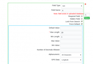
- Latitude field should be named Y and must be set to the GPS Data type of 'Latitude'
- Longitude field should be named X and must be set to the GPS Data type of 'Longitude'

- Field names are not case sensitive. As well, spaces and special characters are also ignored.
i.e. Pole Number, POLE NUMBER, pole number, Pole_Number, PoleNumber are all exactly the same and therefore considered duplicates
- Do not include these field names as they are reserved by the system
- RecordNo
- Latitude
- Longitude
- Date
- Device
Extracting Data From Shapefiles
Map Marker Colors
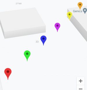
- By default, Golden Retriever sets all supplied coordinates to a Red map marker and completed ones as Green. You may alternately set other colors by defining them (by number) in a MapColor field in your csv file. Green is 'reserved' for completed records. Red, Blue, Purple, Yellow and Orange are currently the other colors available for the 'TO DO' map markers. These are set in the csv which contains the utility supplied data. To accomplish this, add a field (csv only and not in the Dictionary Creator) called MapColor and identify the requested color by its number:
- 0 - Red
- 1 - Green (It is not recommended to use green markers)
- 2 - Blue
- 3 - Purple
- 4 - Yellow
- 5 - Orange

Note: The colors do not show the same on iOS and Android - the colors shown here are how they display on Android.
GPS Coordinate Format
Note: the file must be a CSV (comma delimited and enclosed with double quotes), any coordinates must be in WGS84 format (EPSG:4326), and the column names must match the columns in the dictionary for them to be used by the program.

Once the file has successfully been uploaded the Local Database will show is Database Uploaded. The csv can be removed at any time by clicking the red click to unassign link. You can verify all fields with data by looking for the Note: field exists in uploaded database (in red) statement, located immediately under the Field Name.


Note: For instructions on how to extract pole data from a Utility supplied shapefile and other QGIS specific functions follow these instructions.
Once you have uploaded the csv file and saved the dictionary, the data will be available on the mobile app once dictionaries are refreshed.
If the poles do not show up in the expected location on the mobile app's map it is most likely due to incompatible GPS coordinates. Confirm that they have been supplied to Golden Retriever in EPSG:4326, WGS 84.
